


tremplins D Autrans

jphugon
User
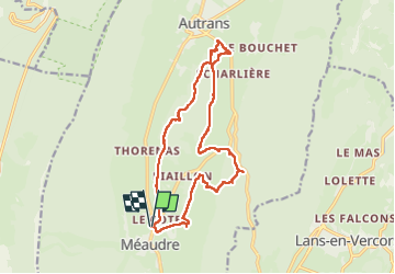

Length
16 km

Max alt
1207 m

Uphill gradient
710 m
Km-Effort
25 km

Min alt
972 m

Downhill gradient
709 m
Boucle
Yes
Creation date :
2025-08-04 06:38:03.61
Updated on :
2025-08-04 13:57:50.177
7h18
Difficulty : Very difficult

FREE GPS app for hiking
 SityTrail
IGN / Geographical institutes
SityTrail Plus
The world is yours!
About
Trail Walking of 16 km to be discovered at Auvergne-Rhône-Alpes, Isère, Autrans-Méaudre en Vercors. This trail is proposed by jphugon.
Photos


Positioning
Country:
France
Region :
Auvergne-Rhône-Alpes
Department/Province :
Isère
Municipality :
Autrans-Méaudre en Vercors
Location:
Méaudre
Start:(Dec)
Start:(UTM)
698763 ; 5000603 (31T) N.
Comments